Table of Contents
Disclaimer and Copyright
Overview
Installation
Simulation Setup
Application Start
Menu Structure
Hard Keys
Main Forms
Position Form
Sky View Form
Navigation Form
Map Form
Map Display
Map Pan and Zoom
Map Storage
Format
Map Scale
Map Database
Installation/Backup
Map Storage on Memory Cards
Map Selection
Approach Alert
Adding Position to Clipboard
Exporting Position via Memo to GeoDB
Option Forms
Misc Options Form
Map Options Form
Data Forms
Waypoints Form
Waypoint Edit Form
Routes Form
Route Edit Form
Tracks Form
Data Exchange
Port Form
Connecting to a Bluetooth GPS
Serial Port Multiplexing
About Form
Supplementary PalmOS Applications
Acknowledgements
References
Abbreviations
GPS4Palm - PalmOS Mapping GPS Application
	* displays GPS information
	* displays current position on map
	* automatic/manual map selection
	* automatic map download from internet
	  using external application FetchMap
	* navigation to selected waypoint
	* navigation along a route
	* track logging
	* waypoint, route, and track data exchange with host

Copyright (c)01/2003 M.Prinke <matthias.prinke(...)surfeu.de>

This program is free software; you can redistribute it and/or modify
it under the terms of the GNU General Public License as published by
the Free Software Foundation; either version 2 of the License, or
(at your option) any later version.

This program is distributed in the hope that it will be useful,
but WITHOUT ANY WARRANTY; without even the implied warranty of
MERCHANTABILITY or FITNESS FOR A PARTICULAR PURPOSE.  See the
GNU General Public License for more details.

You should have received a copy of the GNU General Public License
along with this program; if not, write to the Free Software
Foundation, Inc., 59 Temple Place, Suite 330, Boston, MA  02111-1307  USA


Please do not use this program for navigation!
See GNU GENERAL PUBLIC LICENSE
for complete license.
This is the user's manual for GPS4Palm. It describes the current status of
implementation. This document is accompanied by
| Specs |
| Name | GPS4Palm |
| Version | 0.9.4 beta |
| Creator ID | Gps4 |
| Size | 145KB |
| Palm OS | >=3.0 |
| Libraries | MathLib, ZLib, gpslib |
| Misc | required: GPS Receiver
opt.: FetchMap (Application),
Serial Port Multiplexer
(Hardware),
GPSMan (PC Application) |
The following items have to be installed on the PDA:
- MathLib.prc
- gps4palm/contrib/gpslib-1.33/gpslib.prc
- gps4palm/contrib/palmzlib/SysZLib.prc
(optional, required only for maps in PNG image format)
- only one of the files gps4palm/GCC/GPS4Palm*.prc
(see gps4palm/GCC/README.txt)
- FetchMap.prc (optional)
For testing or evaluating GPS4Palm, no actual PDA, GPS receiver or network
interface (WLAN or mobile phone) is required. See section
Simulation in the
GPS4Palm Development Documentation for
details.
After launching GPS4Palm, a blank screen shows up for a few seconds while the
application preferences are loaded, some libraries are opened and internal data
structures are initialized. Depending on the PalmOS version (or exactly: version
of the Serial Library), either the Port Form will be
opened to let the user select the connection profiles for the serial ports the
GPS receiver and the host are connected to or the default serial port settings
will be applied.
If the GPS4Palm is started for the first time, the Position
Form will be opened. On subsequent starts, the last main form (Position Form, Sky View Form, Navigation Form or Map Form) opened when
the application was closed will be opened again.
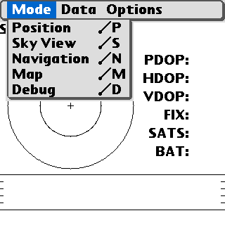
The menu entry Mode allows to select one of the four Main Forms. The menu
entry Data allows to select the Waypoints Form,
the Routes Form, and the Tracks Form
and to copy the current position to the Clipboard or to
the application GeoDB, respectively. The menu entry
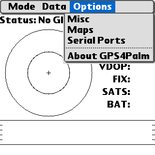
Options allows to access the Option Forms and the About Form.
In addition to these menu entries available on all Main Forms, additional form
specific entries may exist (e.g. the Map Form's Map menu).

 In addition to the menu entry Mode, the hard keys can be used to switch
to any of the Main Forms:
In addition to the menu entry Mode, the hard keys can be used to switch
to any of the Main Forms:
| No. | Default Function | Form |
|---|
| 1 | Calendar | Position |
| 2 | Address Book / Contacts | Sky View |
| 3 | ToDo / Tasks | Navigation |
| 4 | Memos / Notes | Map |
The Position Form shows the following information in textual form:
- GPS Status
- Time (UTC)
- Latitude and Longitude
- Speed Over Ground
- Altitude
- Course Over Ground
- Magnetic Variation
The GPS Status can be
- No GPS!
- No NMEA messages can be received. This means the GPS receiver is either
disconnected, switched off or not powered.
- Warning!
- The NMEA messages indicate that the GPS data is invalid, because the
satellite coverage and/or signal-to-noise ratio is poor.
- OK
- The NMEA messages indicate valid GPS information.
The time is shown as provided by the NMEA RMC message, i.e. HH:MM:SS DD:MM:YY.
Latitude and Longitude, Speed Over Ground and Altitude are shown in user
selected units. See section Misc
Options Form for details.
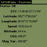
Note: Some GPS receivers do not provide magnetic variation data.
The Sky View Form shows the following information:
- GPS Status
- Time (UTC)
- Position (Azimuth/Elevation) of all satellites in view as "sky view"
plot
- Signal-to-Noise ratio (SNR) for all satellites in view as a bar graph
- Precision of fix (PDOP/VDOP/HDOP, Type of Fix [none, 2D, 3D])
- Number of satellites in view
- Battery voltage (percentage) of the PDA
A description of the Status information can be found in the section Position Form.
The outer circle of the Sky View plot denotes 0° elevation, the inner circle 45°
and the center 90°. The azimuth is shown directly on the circle (0°/north
up).
The SNR is shown as provided by the NMEA message GSV in units of dBHz with a
range of 0..100 (higher means better). Bars of satellites used by the GPS
receiver for the position fix are filled.
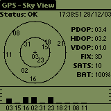
The figure shows the status while the GPS receiver had been attached indoors to
a window facing more or less southwards.
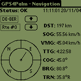
The Navigation Form shows the following information:
- GPS Status
- Time (UTC)
- ID of active waypoint
- Number of active route
- DST: Distance to active waypoint
- SOG: Speed over ground
- VMG: Velocity made good
- TTG: Time to go
- COG: Course over ground
- BRG: Bearing
- TRN: Turn
A description of the GPS status information can be found in the section Position Form. Please note that some information is shown only
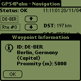
if an Active Waypoint exists. A tap on the Waypoint ID opens a form with
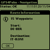
some information about the active waypoint. A tap on the Route Number
opens a form with some information about the active route. Please note that Time
To Go is calculated from the current data (VMG, DST), no filtering
or averaging is done. Speed and distance are always shown in the user selected
units.
The Active Waypoint is selected depending on the navigation mode:
- Waypoint Navigation:
A waypoint has been selected as the Active Waypoint (destination) on the
Waypoints Form. This waypoint will remain active until
another waypoint is selected or an Active Route is selected.
- Route Navigation:
A route has been selected as the Active Route on the Routes Form. The first route waypoint is set as the initial
Active Waypoint. If automatic waypoint selection has been enabled in the
Misc Options Form, the Active Waypoint is set to
the next route waypoint if the distance to the current Active Waypoint is
increasing while the distance to the next waypoint is decreasing, i.e. the
current Active Waypoint has been passed by.
Manual selection of the Active Waypoint of the Active Route is
always possible with the Arrow Up/Arrow Down buttons.
The Active Route is disabled by selecting an Active Waypoint
(destination) on the Waypoints Form (i.e. switching to
Waypoint Navigation)
Distance and direction to the waypoint are calculated using great circle
formulae, i.e. the route to the waypoint is the orthodrome. A spheroidal model
of the earth is assumed, but the distance calculation is slightly corrected by
using the radius of the Earth at the latitude of the current position according
to WGS84 in the calculation.
The ring shows the Course Over Ground (COG) in compass fashion, i.e. the
heading is read from the top of the ring. The pointer in the inner circle shows
the Bearing (BRG): it points straight upwards if COG=BRG.
| 
| 
|
| Navigation Form
| Navigation Form,
Waypoint Info
| Navigation Form,
Route Info
|
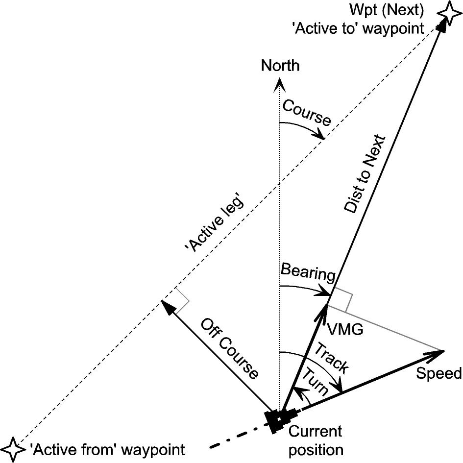 |
Navigation Terms
(with kind permission from Sigurd Humerfelt) |
The Map Form displays the current position on a map. The map is rendered from a
raster image (GIF or PNG format). A High-Density Display is supported if
available (e.g. 320x320 pixels on a PalmOne Tungsten T3). The scale and center
coordinates of the map as well as the coordinates of the current position are
printed on the map. The GPS receiver status is currently not shown.
Currently the text might cover important parts of the map. A smart text
overlay technique still has to be implemented. In addition to the
map/position data, other information (e.g. concerning active waypoint)
has to be taken into account.
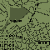
The map size may be greater than the screen size. Initially, the map is
centered. By tapping with the stylus on the map, the center can be changed
(panning).
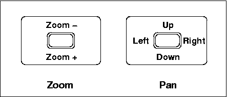
Using the up/down hardware keys, the map can be zoomed. It is only possible to
zoom out from the original size in integer steps (1..8). Zooming is implemented
by sub-sampling the image without filtering - the algoritm is fast, but the
result is usually not very appealing. However, the functionality is
sufficient to gain an overview of a large map.
The FiveWay controller is supported if available. Pressing the center button
toggles between Zoom and Pan mode:
Caution:
Currently map panning is possible to view a map, but not handled
correctly by the position display function. Therefore it is recommended to use
maps equal to the screen size (160 x 160 pixels on standard screen, 320 x 320 or
greater on high-density screen) to avoid confusion.
The maps are stored as a File Stream PDB (actually containing a GIF or PNG
image) with Type-ID "DATA" and Creator-ID "BOXR". The latter has been chosen to
allow interoperation with the program ZBoxZ for up-/downloading maps from/to the
desktop and to allow removing maps from the PDA.
The PDB name (max. 31 characters) should be in the format
<scale><latitude><longitude>.gif
to store the geographic reference data in the filename.
- <scale>
- either an integer or an integer followed by the letter k (x 1,000)
or by the letter M (x 1,000,000)
- <latitude>
- latitude in degrees, positive: northern hemisphere / negative: southern
hemisphere
- <longitude>
- longitude in degrees, positive: eastern hemisphere / negative: western
hemisphere
Examples:
  200M-52.1614999-110.3126601.gif
  200M+52.1614999+110.3126601.gif
In addition to the center position, the scale has to be set correctly in order
to use a digital map with GPS4Palm properly. The scale of a (paper) map is
defined as:
scale = d_real / d_map
with:
- d_real
- distance in reality
- d_map
- distance on map
For a digital map, the distance on the screen is:
d_screen [pixels] = d_map [m] * r_map [dpi] * (1/0.0254) [1/m]
with:
d_map = d_real / scale
and
- r_map
- resolution of digital map, typically in dpi (dots per inch)
Note: GPS4Palm assumes a map resolution of 72 dpi, otherwise geo
referencing will not work correctly!
Any suitable PNG or GIF map file can be converted to a PDB file for use with
GPS4Palm. The image file should be renamed as described in the section Map Storage Format to allow geo referencing. The programs
linbox/winbox/macbox allow to convert the image file to a Palm Database file
(PDB) on differrent host operating systems, while linunbox/winunbox/macunbox
convert from PDB to a regular image file. These programms are included in ZBoxZ.
The generated PDB files can be installed from the desktop to the PDA like any
other Palm OS file and retrieved from the PDA during hotsync or backup.
GPS4Palm allows to store maps on external memory cards (e.g. SD-Cards) if the
PDA provides this feature (in PalmOS terms: Virtual File System). The map image
files must be located in the directory /PALM/Programs/gps4palm/.
The images must be stored as GIF or PNG files (not PDB files!). The file names
must be chosen as described in section Map Storage
Format to allow geo-referencing.
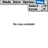
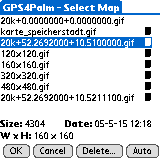
The Map Form provides a Map menu entry. The menu item Select opens
the Map Selection Form, which shows a list of all map files available as
databases (PDBs) in internal memory or as regular GIF/PNG files on external
memory card (if supported). In the latter case, a card icon is shown next to the
filename.
The size (in bytes), the dimensions (in pixels) and the time and date of
creation of the selected file are shown at the bottom. By selecting a filename
and tapping the OK button, a map file is selected and GPS4Palm switches
to user selected mode. In user selected mode, the selected map is shown
independently of the current position, selected scale or a valid geo reference.
The Cancel button allows to leave the Map Selection Form without changing
the current map or the map selection mode.
A map file can be deleted by tapping the Delete button. A confirmation
request which shows the name and storage location (internal memory or
memory card) of the selected file is opened.
Automatic map selection is activated with the Auto button. In
auto map selection mode, all files with appropriate geo reference (see
section Map Storage
Format) are examined. The first map with the selected scale (see
section Map Options Form)
showing the current position is selected. If no suitable map is found on
the PDA, the download policy (see section Map Options Form) determines
further actions.
If downloading is enabled (and optionally confirmed by the user), the external
application FetchMap is invoked to download a new map with the selected scale
and the current position at the map's center from a web server. FetchMap stores
the map file with a database name/file name as described in section Map Storage. If FetchMap has successfully completed the web
access, GPS4Palm switches to the new map. If FetchMap failed (because connection
to the internet could not be established or the web server could not be
reached), GPS4Palm will not try again to start fetchmap unless the user selects
the menu entry
Map->Fetch explicitely.
If no suitable map is available, because download is disabled or failed,
the screen is cleared and the message "No map available!" is shown.
Please note that the PDA's serial port might have to shared between the GPS
receiver and the network interface (e.g. mobile phone, modem). See section Serial Port Multiplexing for details.
Note: The message "No map available!" does not mean that no map is
available at all, but that no map with the desired scale for the current
position is available (automatic map selection) or that no map has been selected
yet (manual map selection)!
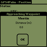
If selected in the Misc Options Form, an Approach Alert
will be issued when the Active Waypoint (see Navigation
Form) is approached and one of the Main Forms (Position
Form, Sky View Form, Navigation
Form or Map Form) is currently open.
The approach distance is either the Proximity Distance stored in the waypoint
record (see Waypoint Edit Form) or the default
approach distance (100 meters) if the Proximity Distance is zero. Please note
that the Proximity Distance is always set to zero by downloading Waypoints from
the host to GPS4Palm.
Depending on the settings in the Misc Options Form, the
Approach Alert can be audible and/or visible:
- only Approach Alert checked:
A form is opened with the Active Waypoint ID and the current distance to it. The
distance is updated continuously until the Approach form is closed. An Approach
Alert will be triggered again only after the Active Waypoint has changed.
- both Approach Alert and Alarm symbol checked:
same as above, but an audible alarm is generated each second until the Approch
form is closed.
- only Alarm symbol checked:
An audible Alarm is generated once when the Approach Distance is reached. No
further alarms will be generated until another waypoint is set as Active
Waypoint and the new waypoint's Approach Distance is reached.
- otherwise: no alert
 The menu entry Data->Pos. to Clip. allows to copy the date and time of
fix and the current position to the Clipboard.
The menu entry Data->Pos. to Clip. allows to copy the date and time of
fix and the current position to the Clipboard.
Date and time have the format Y-M-D H:MM, the position format depends on
the settings of the Misc Options Form.
The menu entry Data->Pos. to GeoDB allows to copy the current position
to a memo which in turn can be imported to GeoDB.
The memo has the following format:
Gps4<newline>
_GPS4Palm,DD:MM.MMMM,<N|S>,DDD:MM.MMMM,<E|W>,,,,,
Please refer to the GeoDB documentation for more details.
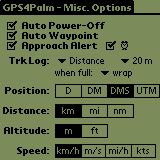
The Misc Options Form allows to disable auto-power off while GPS4Palm is
running, enable/disable automatic waypoint selection in route navigation mode
(see Navigation Form), to set the Approach Alert options
(see section Approach Alert), to set the Track Log
options (see section Tracks Form) and to select
the preferred units for data display.
The following position formats are available:
| Abbr. | Units | Example:
|
|---|
| D | Degrees | N40.1793254°
E132.8627439°
|
| DM | Degrees and Minutes | N40°10.7596'
E132°51.7646'
|
| DMS | Degrees, Minutes and Seconds | N40°10'45.572"
E132°51'45.878"
|
| UTM | Universal Transversal Mercator
Zone Designator and Number,
Easting and Northing | 53T 318035.4
4449851.1
|
The position shown always refers to the WGS84 coordinate system. UTM is
restricted to latitudes from 80°S to 84°N. In some cases, a sign is used instead
of the letters N/S and E/W according to the following convention:
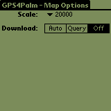
 The Map Options Form allows to select the preferred map scale and the map
download policy. If the Map Form is selected and automatic
map selection is enabled (see section Map Selection), the
download policy specifies what is done if no map with the selected scale is
available for the current position:
The Map Options Form allows to select the preferred map scale and the map
download policy. If the Map Form is selected and automatic
map selection is enabled (see section Map Selection), the
download policy specifies what is done if no map with the selected scale is
available for the current position:
- Auto
- Map download starts automatically without request.
- Query
- Map download has to be confirmed by the user.
- Off
- Map download is disabled
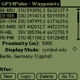
 The Waypoints Form allows to add, remove and view waypoints. Furthermore, it
allows to select a waypoint as "Active Waypoint" used as destination in the
Navigation Form.
The Waypoints Form allows to add, remove and view waypoints. Furthermore, it
allows to select a waypoint as "Active Waypoint" used as destination in the
Navigation Form.
Each table row shows waypoint ID, latitude and longitude (or ID, field, easting
and northing if UTM has been chosen as position unit). Below the table, the
proximity distance, display mode (currently not used) and comment for the
selected waypoint is shown.
During route, waypoint or track transfers (see section
Data Exchange, status information is shown
next to the label Xfer.
The buttons below provide the following functions:
- New: Add a new waypoint (starting from a template).
- Copy: Create a new waypoint, starting with data from selected one.
Used for modifying an existing waypoint as well.
- Delete: Delete selected waypoint.
- Go To: Choose selected waypoint as "Active Waypoint",
disable "Active Route" and switch to Navigation Form.
Please note that a waypoint cannot be deleted if it is part of any route. In
this case, an alert informs about the first route which contains this
waypoint.
Tapping the button New or Copy switches to the Waypoint Edit Form. All waypoints are kept in a single
Waypoint Database (Name: "Waypoints-Gps4", Type: WAYP).
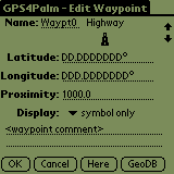
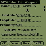
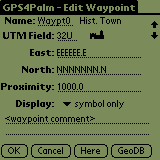
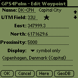
The Waypoint Edit Form allows to enter a new waypoint into the database.
Depending on the selected function in the Waypoint Form (New or
Copy), editing is started either from a template indicating format and
precision of the coordinates or from an existing waypoint.
The values entered into the coordinate fields are validated if either the field
is deselected or the button OK is pressed. If the entry is invalid, the
previous entry is restored. Since specific restrictions apply to UTM
coordinates, the waypoint data entered may not be accepted even if the separate
entries for the fields UTM Field, Easting and Northing
have already been accepted. In this case, tapping on the OK button will
not close the form until the waypoint data is valid or discarded.
In addition to the position, a waypoint consists of a Waypoint Name (up
to 6 characters), a Proximity Distance (in meters; denotes the required
distance until the waypoint is considered to be reached), the Display
Mode (currently not used) and a comment (up to 39 characters).
The button OK adds the new waypoint to the database. The button
Cancel discards the data. Tapping either OK or Cancel
switches to the Waypoints Form. The button Here copies the coordinates
of the current position to the fields. This works only if the current GPS
status is valid. The button GeoDB copies the coordinates and additional
information of the location selected in GeoDB to the
fields, provided that GeoDB and a suitable database are installed.
| 
|
New Waypoint
(Position Unit: Degrees)
| Copy Waypoint
(Position Unit: Degrees)
|
| 
|
New Waypoint
(Position Unit: UTM)
| Copy Waypoint
(Position Unit: UTM)
|
The Routes Form lists all available routes and allows to add and delete
routes. Furthermore, it allows to select a route as Active Route used for
navigation (see Navigation Form) provided it contains at
least two waypoints.
Each table row shows route number (0..255), a route comment and the number
of waypoints on the route. The route number is either determined upon
downloading a route from the host or created automatically (lowest unused
number) upon creation of a new route. The comment of an Active Route is
shown in bold.
During route, waypoint or track transfers (see section
Data Exchange, status information is shown
next to the label Xfer.
The buttons below provide the following functions:
- New: Add a new route.
- Edit: Edit or view a route.
- Delete: Delete selected route.
- Select: Choose selected route as "Active Route".
Tapping the button New or Edit switches to the Route Edit Form. All routes are kept in a single
Route Database (Name: "Routes-Gps4", Type: ROUT).
The Route Edit Form allows to create a new route or to modify an existing one.
The current route number and the route's comment is shown in the first line, the
latter can be edited.
The table on the left shows all waypoints available in the waypoint data base.
The table on the right lists all waypoints which are part of the selected
route.
Waypoints can be added to the route with the Add-> button, the selected
waypoint from the left is inserted after the selection on the right.
The Arrow Up/Arrow Down buttons allow to move the selected
waypoint up or down in the route. A waypoint is deleted from the route using the
Del button. When finished, tapping the Done button switches back
to the Routes Form.
The Track Form allows to create a new (empty) track, to delete a track and to
start/stop logging. The table shows a the track's comment on the left and the
current number of logged track points on the right. The default track comment
(max. 49 characters) can be edited as desired.
The Active Track (i.e. the track selected for logging) is shown in bold.
Track points are logged only while any of the main forms (Position Form, Sky View Form, Navigation Form or Map Form) is selected.
The logging can be stopped and resumed later, even after exiting and re-opening
GPS4Palm.
During route, waypoint or track transfers (see section
Data Exchange, status information is shown
next to the label Xfer.
The buttons below provide the following functions:
- New: Add a new track.
- Delete: Delete selected track.
- Start/Stop: Start/Stop logging to "Active Track".
All track comments are kept in a single Track Header Database (Name:
"Trkheaders-Gps4", Type: TRKH). The track points are kept in a separate Track
Point Database for each track (Name: "Trkpoints-Gps4-xxxxxx" [xxxxxx: hex
number, 6 digits], Type: TRKP).
The Misc Options Form allows to select the log
mode (time or distance) and the log interval. Additionally, the behaviour upon
reaching the maximum number of track points (65534 points per track) can be
specified: logging will either be stopped or logging wraps to the log's start.
| 
|
Tracks
(Logging stopped)
| Tracks
(Logging started)
|
Waypoints, Routes, and Tracks can be transferred from a host (desktop computer)
to GPS4Palm and vice versa using the Garmin protocol. This
allows to use a variety of applications written for Garmin's handheld GPS
devices, such as GPSMan (see References). Before
starting a waypoint, route or track transfer, either the Waypoints Form, the Routes Form
or the Tracks Form has to be selected.
The data is transferred using the selected serial host interface (see Port Form) at 9600 baud. If a serial multiplexer is used,
the host is connected instead of the GPS receiver (see section Serial Port Multiplexing).
GPS4Palm provides the following product data information over the Garmin
protocol:
GPS product ID: 72
Software version: 100
Product description: GPilotS manager
(This information is determined by the library gpslib which provides the Garmin
protocol functionality.)
Note 1: The proximity distance information currently cannot be exchanged
using the waypoint transfer protocol. The track comment information currently
cannot be exchanged using the track transfer protocol.
Note 2: Due to a bug in gpslib, the host does not get a proper response
when requesting data but the there is no data available.
Note 3: Due to a bug in gpslib, it is not possible to retrieve a full track
point database from GPS4Palm. The upper size limit is currently unknown.
Note 4: A bug in the Serial Port Driver of PalmOS V5.2.1 on the Palm
Tungsten T3 prevents gpslib (and other communication software as well) from
working (see GPilotS Bugs page for a short note).
As a workaround,
either connect the RTS and CTS signals of the Tungsten T3 (this conflicts with
the Serial Port Multiplexing option) or buy the bug fix
SerialFix by Larson Computing. Yes, you have to pay for it.
Shame on Palm for not providing a patch!
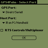
The Port Form will be opened on the first application start-up or by selecting
the menu entry Options->Serial Ports if the New Serial Manager is
provided by the PalmOS version installed on the PDA. It allows to select
different serial port settings for the GPS receiver and for data exchange
with the host from the connection profiles set up in the Connection Preferences
Panel.
It has to be ensured that the GPS connection is configured to the
appropriate baud rate (usually 4800 baud for NMEA compliant GPS receivers). The
host port uses a fixed rate of 9600 baud.
The check box RTS Controls Multiplexer can be enabled to use the RTS
output for controlling an external serial port multiplexer. (see Serial Port Multiplexing for details)
| Port | Baud Rate | Usage | Protocol |
|---|
| GPS Port | 4800 baud | GPS Data | NMEA |
| Host Port | 9600 baud | Waypoint,
Route,
and Track
Data Exchange
with Host (e.g. PC) | Garmin |
Note: PDAs without the New Serial Manager Feature Set (e.g.
Handspring Visor [Deluxe]) provide only a single serial port. On those devices,
the PortForm is not available.
Note: Both GPS Port and Host Port configuration are completely
independent of the serial port (if any) selected as part of the Network
Connnection used by FetchMap.
The Port Form's serial port selector triggers provide all connections available
from the Configuration Panel Communications/Connections. The connections list
can contain serial port, infrared, and Bluetooth based connections. However,
adding a Bluetooth based connection seems to work only for certain classes of
devices such as mobile phones, desktop computers or PDAs, while a GPS receiver
is not found in the search dialog -- even if it has already been set up as a
trusted device in Communications/Bluetooth.
As a workaround for establishing a connection to a Bluetooth GPS receiver, just
select an arbitrary Bluetooth connection in the Port Form (e.g. "BT to <any
mobile phone>"). When tapping the OK button, the GPS receiver will appear in
the list of available, known or trusted Bluetooth devices and can be selected.
GPS4Palm saves the Bluetooth Device Address of the selected GPS receiver. This
allows to reconnect automatically without any user intervention after leaving
and restarting GPS4Palm. The saved Device Address is updated upon selection of
a different Bluetooth GPS receiver from the Port Form.
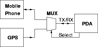
Downloading maps from Internet may require multiplexing of the PDA's serial
port between GPS receiver and the network interface (mobile phone, modem),
because most (if not all) PalmOS PDAs provide only a single serial port.
Newer PDAs provide the Connection Manager with a list of several serial
connection types (such as Cradle/Cable, Bluetooth, Infrared) and connection
targets (to Modem, to PC/Handheld, to GSM Phone). If different physical -- or in
case of Bluetooth logical -- connections are used for the GPS receiver and the
network connection, no serial port multiplexer is needed.
Examples:
- GPS via serial port, GSM phone via Bluetooth
- GPS via Bluetooth, GSM phone via serial port
- GPS via Bluetooth, GSM phone via Bluetooth
If however both the GPS receiver and the network connection have to share a
single serial port, a multiplexer is needed or the user has to plug and unplug
the peripherals manually or to use a mechanical switch. The actual multiplexer
hardware required depends on the logic levels of all interfaces. The PDA must
provide an output port to control the multiplexer's select input. Unfortunately,
if and how this works depends on the specific PDA model used, i.e. the required
code cannot rely on a common PalmOS API function.
Recent devices with the New Serial Manager Feature Set allow to control the RTS
output from the Serial Manager API. If the check box RTS Controls
Multiplexer is activated on the Port Form, the RTS
output is kept inactive (low level, "flow off"-state) by GPS4Palm. When the
network connection is established, RTS is activated (high level, "flow
on"-state). Thus, RTS can be used to control a serial port multiplexer.
In this case, Hardware Flow Control has to be disabled for the network
connection, otherwise RTS will be deactivated as soon as the PDA's receive FIFO
is full. Consequently, the baud rate has to be kept low enough to prevent FIFO
overflows. Also see Note 4 in section Data Exchange
for caveats on Palm Tungsten T and T3.
An example multiplexer circuit for the Handspring Visor (Deluxe) can be found
in the GPS4Palm Development Documentation.
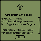
The About Form displays the GPS4Palm logo, version number and copyleft
information (see GNU GENERAL PUBLIC LICENSE
for complete license).
The following PalmOS applications might be useful in conjunction with GPS4Palm:
I would like to thank (in no particular order):
- Jean-loup Gailly and Mark Adler
for the zlib library
- Bill Ezell
for fp.c (Double to String/String to Double Conversion Routines)
- Ed Williams
for the Aviation Formulary
- Fritz Ganter
for gpsdrive, which gave me the initial idea for this
programm.
- Rick Huebner
for MathLib
- Sigurd Humerfelt
for the kind permission to use his drawing "Navigation Terms" in this manual.
(Original title: "Some navigation terms used in the Garmin GPS 12 MAP and GPS
III (PLUS) receivers.", see http://home.online.no/~sigurdhu/Garmin_12MAP.htm)
- Neil Rhodes and Julie McKeehan
for some very useful code snippets from examples for the book "Palm OS
Programming (2nd edition)"
- Tom Zerucha
for ZBoxZ/PiNGer which is the base of the map display and the file browser code
in GPS4Palm.
- Miguel Filgueiras
for the GPS data management application GPSMan
- Christian Claveleira
for the GPS communication library gpslib
- David W. Bray
for GeoDB and the kind support while implementing the location import interface
- Mark Lillywhite and Michael Nordström
for plucker, an excellent Offline-Browser/File Reader (where I got the
5-Way Controller code from)
- BRG
- Bearing. Direction from current position to destination
(e.g. active waypoint).
- CMG
- Course Made Good (also: Track, COG)
- COG
- Course Over Ground (also: Track, CMG)
- DOP
- Dilution Of Precision. Indicates quality of fix depending on geometry of
constellation of satellites in view.
- DST
- Distance
- DTK
- Desired Track
- GIF
- Graphics Interchange Format
- GGA
- Global Positioning System Fix Data. NMEA-0183 sentence format.
- GSA
- GPS DOP and active satellites. NMEA-0183 sentence format.
- GSV
- Satellites in view. NMEA-0183 sentence format.
- HDOP
- Horizontal Dilution Of Precision.
- NMEA
- National Marine Electronics Association. Throughout this document, NMEA
refers to the NMEA-0183 message format used by GPS receivers to transmit data
to external devices.
- PDA
- Personal Digital Assistant
- PDOP
- Position Dilution Of Precision
- PNG
- Portable Network Graphics
- RMC
- Recommended minimum specific GPS/Transit data. NMEA-0183 sentence
format.
- SNR
- Signal to Noise Ratio.
- SOG
- Speed Over Ground
- TRN
- Turn. Angle between COG and BRG. The direction (right or left) indicates
the direction to steer to decrease TRN.
- TTG
- Time To Go
- UTC
- Coordinated Universal Time or UTC, also sometimes referred to as "Zulu
time", is an atomic realization of Universal Time or Greenwich mean time, the
astronomical basis for civil time. Time zones around the world are expressed as
positive and negative offsets from UT. UTC differs by an integral number of
seconds from atomic time and a fractional number of seconds from UT1. (Excerpt
from http://en.wikipedia.org/wiki/Utc)
- UTM
- Universal Transverse Mercator. Denotes both a grid reference system
(comprised of Field [Zone and Belt], Easting and Northing) and a specific map
projection.
- VDOP
- Vertical Dilution Of Precision
- VMG
- Velocity Made Good. Velocity component in direction of destination.
Have a look at my homepage for
updates and other interesting things. For comments or suggestions send me an email.
http://members.surfeu.de/matthias.prinke/gps4palm_e.html
© 02/2003 M.Prinke <matthias.prinke(...)surfeu.de>
| created: | 2004/01/03 17:45:00
|
| last update: | $Date: 2005-05-28 10:21:52 $
|
| $Revision: 1.19 $
|